
Monday, December 28th, 2015
| Subject: two
more North Country reports from Chip Cunningham
W1321
From: Chip Cunningham
Sent: Wednesday, December 23, 2015 1:08 PM Subject: Another log For next week's Whiffle.
Well, no GPS charts with this one, but I like it
nonetheless. Never a
Dull Moment—Two Daysail Venues on the Great Lakes,
2015 Earlier this year in July, Gary Hirsch and I spent seven days, Gary on Blue Rose and me on Solje, cruising the North Channel of Lake Huron. One evening I told Gary a story. As a kid I skied more days than not during the winter. I would take the afternoon school bus to the ski area just outside of town. My dad would stop by on his way home from work and pick me up. Earl (Joe Sr., as he likes to be called) Schnur, a Wayfarer champion from Lake Orion, designed the 30 meter ski jump built there. I didn’t know him then, but I sailed off the end of his jump on a pair of gigantic old wooden jumping skis over and over. Almost sixty years later just by luck I met Joe Sr. and he took me out for my first sail in Solje. Anyway, the end of the story is, one winter my dad took all of us kids out to Colorado to ski in the Rockies. I told Gary, “I never skied in Michigan again.” Gary said, “This cruise may be like that.” Indeed.
It was transformational for me. I haven’t been back to
Lakeville Lake, the lake near my house, since. I used
to go at least a couple of times a week. Now bigger
water has my eye: that was the lure of a boat in the
first place. The romance of actually going someplace…. 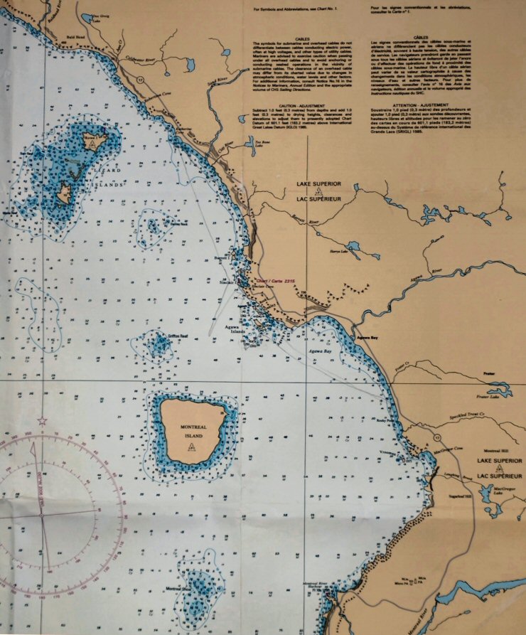 Every
mid-August for 25 years now Sky has gone to Lake
Superior Provincial Park at the east end of the lake
to kayak. This year, stoked by the success of the trip
with Gary, she and I went together and took Solje
too, the idea being that we would finally sail
together. There is a protected boat launch in Sinclair
Cove about 6NM by water northwest of the campground at
Agawa Bay. The first day there I sailed out of the
cove, outside the Agawa Islands in a steady 10 knots
of south wind and across Agawa Bay to our campsite.
The surf was calm enough to beach Solje on
the pebble shore right in front of our tent. Sky got
in and we sailed back through the Agawa Islands, past
native pictographs drawn on a vertical granite wall at
the water’s edge, to the cove. 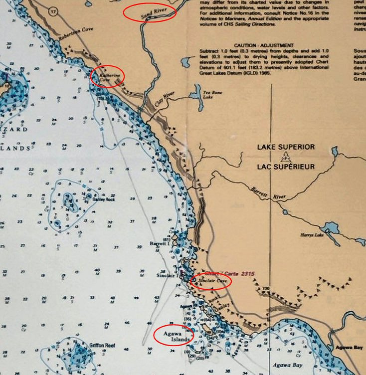 Alas,
the wind and waves picked up steadily the rest of the
week and that was our only sail together. Heartbroken
as I was, I sailed solo five of the six remaining
days. One trip was a difficult beat 5NM north along a
spectacular coast past the Sand River to Katherine
Cove (above). 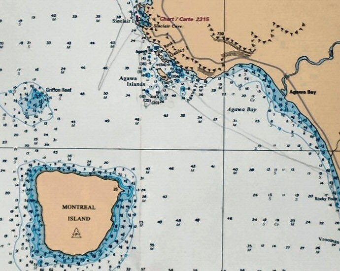 The next day was a 4NM crossing out to Montreal Island. The waves were 4 feet or more and brought a panicked realization that rocks that look deep enough on the crest look suddenly very shallow in the trough! I had a terrifying vision of the centerboard getting stuffed up through the case as Solje dropped onto the bottom: a good reason to sail conditions like that with the board a little up so it will fold. The water is shallow far off the island and it turned into a long sail around. A curious strand extends northeast off the island in the direction of the Agawa River 3.5NM away. It stands well out of the water like a jetty built out of good sized stones. The park rangers say it is evidence of the force of the river’s spring flow. Two
other days of medium gusty wind were spent sailing
around and through the Agawa Islands. One island has a
long flat vertical wall that must be 100 feet high. It
plunges straight into the water. You can draw your
palm along it as you glide by. The last day was downright blustery. Sinclair Cove is inside high cliffs and they confuse the wind. It was a trick to sail out of, and as soon as I got out, I wished I hadn’t. Gusts were a mounting concern. The cliffs were too close on either side to risk gybing around to go back in, so I sailed farther out for enough sea room to heave to and reef the main, which in that wind was a good way out. The working jib was already on. The waves were very big by then—the biggest yet. I remember telling myself that I just had to trust that Solje would stay upright on top of them and that I needed to concentrate on getting the reef in fast. It was quite a ride, but Solje handled it and I got the main reefed. In that short time, however, the wind had come up even more and I hove to again for a second reef. This can be called “chipping away” at the problem. Finally I felt in enough control to sail back into the cove. That was not exactly fun. You might be thinking, “Well, he should pay more attention to the weather.” Well, Sky and I check the marine forecast every morning and if there’s something developing, we check it again. To get the weather we listen to the weather radio. The Environment Canada Meteorological Service broadcasts, of course, in French as well as English. Whenever we turn it on it is always happening in French and we have to wait for the English to come around. If you don’t pay attention during the French, you will probably miss the first couple days of the English forecast. The French version lasts far longer than the English. One morning a francophone acquaintance helped us understand why. He said that the French speaking weatherman was actually complaining about his girlfriend’s mother. She had recently moved in with them. Trying to find a larger apartment was driving him to misery. Toronto is not fit for human habitation. Ontario tobacconists are worthless for not carrying Gauloises cigarettes. Niagara Region wine is for hot dogs. Finally he directed a tirade at someone who had called the Service asking if he would please just get to the weather. He ended, “Qui pense je suis—sa mère? Allez à la fenêtre et regardez!" The Service would do well to take his last bit of advice. During our trip to Lake Superior, the English version of the weather report got stuck on Thursday. In English, “today” was still Thursday all through Friday, Saturday, Sunday and Monday—the day of the big wind—with no updates. French speakers, as near as we could tell, moved on normally. And on our later second trip to Canada, we listened one day at 6:00PM to an elaborate forecast just issued at 5:40PM which perfectly described the weather that had already happened that afternoon. Most sailing along the east shore of Lake Superior is big water on one side and big rocks on the other. Sky still wanted to sail but not in that. On the drive home we talked about someplace more sheltered. The part of the North Channel that Gary and I sailed had longer crossings and rougher conditions than Sky cared for, but an old Richardson’s Chartbook showed a promising bay at the east end of the channel. It was so dense with islands it was named Bay of Islands. The only chart for it was from the year 1885 and, on top of giving very few soundings, it didn’t even show all of the bay. When we got home we read about the Bay of Islands in a guide for the North Channel, Well Favored Passage, by Marjorie Cahn Brazer that Gary had loaned me. The guide was not enthusiastic about it mainly because of its lack of charting, although a locally produced chart was said to be available at Turner’s, a general store in Little Current. It was recommended for the “adventuresome.” Good enough for me! Many people we talked to had Bay of Islands confused with McGregor Bay. Bay of Islands is to the north and west of La Cloche Peninsula. McGregor Bay is to the east. There is a low, narrow viaduct that connects the two at Swift Current at the bottom of La Cloche Channel, but going out around through Little Current is the usual way between them. Summer was getting on toward Fall so Sky said, “Look for housekeeping cottages to rent.” Google Earth is a great asset. Our search of the area soon zeroed in on Whitefish Falls, a small village at the mouth of the Whitefish River at the head of the bay. Two places offered housekeeping cabins each along their side of the river. We arrived Sunday evening the thirteenth of September. The next morning we decided to move across the river to the Bay Villa Lodge. It is hard to imagine how things could have been better. Don and Judy Datz who run the place provided just what we had hoped for—a warm welcome and a clean rustic minimalist cabin. The vacation season was winding down quickly. Only two other cabins were occupied and we were the only one by the end of our stay. The last night of our week’s rental we listened to another glowing weather forecast for the next day. We looked at each other and at the same time said, “Let’s stay one more day.” I’m telling you: this place is really a good deal. The falls tumble through a long steep chute about a mile upriver. We launched Solje and tied her up to a slip 25 feet from the cabin door. Provided with a xeroxed copy of the local chart we headed out into the maze of islands in a sunny 75 to 80 degrees with 12 knots from the west to southwest. All eight days but one were like that! I have not yet and may never learn how to sail Solje without having her tip one bit, and Sky doesn’t like that. My only hope is that someday she gets comfortable with it. The spate of capsizings I went through early on in my sailing career might have something to do with it. Whatever. We sailed early in the morning and late in the evening a few times and then she rented a kayak. I went on alone to sail in the morning for a few hours, in the afternoon for a few more hours and then again in the evening. Sky and I have been together for over forty years and raised three kids, so my lingering hope that we can one day literally be in the same boat together is not altogether unfounded. One Canadian friend had given us the impression that the islands of the bay were thick with large cottages owned by rich Americans, and although there are more cottages here than farther up the North Channel, our experience was that, rich Americans notwithstanding, there are still plenty of empty islands and secluded areas. It would not be a problem to camp on a boat throughout the bay. The scenery was just as beautiful and varied as the rest of the channel, and had the additional benefit of a background provided by the white quartz La Cloche Mountains rising from the north shore. Through the height of summer you might have to endure adolescent reveling or maybe evenings of drunken fishing songs like Jumpin’ Muskies, or A Hundred Cans of Worms on the Wall, but spring and fall are quiet and lightly populated. Friday,
the one rain day, we drove into Little Current and at
Turner’s bought a copy of the first definitive
Canadian Hydrographic chart of the area, Chart 2207
issued in 2001. Local people remember surveyors
combing the bay for years to produce the chart. We
also discovered a small but well-stocked health food
and local food store called The Island Jar. They have
a restaurant that sells the best samosas! 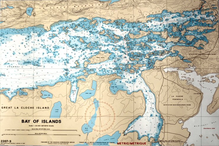 - click here
for larger image
The Whitefish River is mainly a base for sport fishermen and island cottagers who favor the speed of an outboard, so Solje attracted a bit of attention and we made friends with some interesting local people. We were told that we were sailing in areas that people with motorboats don’t risk going. One friend said that he doesn’t take his boat into water less than six feet deep: wind and waves can change depths quickly. Friday’s wind, strong out of the north, showed us what he meant. When we got back from the car trip to Little Current the docks in the river were high out of the water and the bay was sprinkled with rock outcroppings we had not seen before. I measured the depth of the water in front of the cabin with a carpenter’s tape right about the time the wind quit. In the next hour the water came back up sixteen inches! So, sailing beyond the buoyed channel is a calculated risk. In the right light it is possible to spot shallows and some shallow areas extend, as you might expect, away from sloping islands. For those it is possible to dump the sails and glide with little power through them. The centerboard often bounces up and rarely the rudder too. But many occur unanticipated in the middle of broad open areas. A few are marked by the odd plastic bottle buoy. Most are not. Those are the ones I hit going a little faster than I wished. Even so, I sailed everywhere I wanted—through channels barely wider than the boat, through grassy places, over and between rocks into the most beautiful pools. When I redid Solje’s bottom three years ago I gave her five coats of epoxy mixed with aluminum powder for abrasion resistance and it really worked! Her bottom was scuffed here and there but none of the scuffs were through to wood. The centerboard was another matter. I joked with Sky on the way home that I should beat the edge of an old piece of plywood with a hammer and include a picture of it with this article as what was left of the centerboard. When I got home and crawled under the boat for a look I was shocked to see that I didn’t need to exaggerate anything—a good eighty percent of the leading edge of the board was gone! Never fear! Three days later it was fixed and faired with a new leading edge of epoxy and aluminum powder—better than ever. And, man, was it ever worth it. I sailed without the chart. I am staunchly non-GPS: it really kills the fun. So finding my way through the islands was a huge wonderful puzzle. It took me a while to realize that no matter how lost I got, the mountains were always visible, and that the Whitefish River was at the east end of them. I got pretty familiar with the bay around the river and the last few days stayed out until dark. There was a lighted daymark on a rock in front of our cabin that came on about an hour after sunset. It was so friendly to see—like its light was calling, “Here. Here. Here….” |
| Subject: |
| Subject: |
| Subject:
|
| Subject: |
| Subject: |
| Subject: |
| Subject: |
| Subject: |
| Subject: |