|
A Dinghy Sailor's Sketches of
Chesapeake Bay
by Dick Harrington Part One For
a brief period of time my eldest granddaughter,
Caia, who lives with her parents in Gettysburg toyed
with the idea of taking a short overnight cruise
with grandpa on Blue Mist.
She and her sister, Marissa, the next oldest of my
ten grandchildren, had day-sailed with me previously
on the Chesapeake. It wasn't too crazy of an
idea I thought for a mature 13-year-old who enjoys
Girl Scouting and camping. But in the end, the
difficulties of trying to work around the
complexities of an active teenager's calendar were
too much. So with no entanglements to hinder
me, I set my sights for distant places--destinations
I had not yet seen. I was about to disappear
and become a seafaring nomad for the next week and a
half, by the end of which, I'd look like it too,
sunburned with an overgrown bush-beard and badly in
need of a haircut. It was a grand adventure.
 The
eastern shore will always be my favorite Chesapeake
Bay cruising territory. This is the quiet
side, with vast marsh wilderness areas that teem
with wildlife and where those who make their living
on the water still dominate. Recently I'm
seeing increased pressure from big money developers
on the other side of the bay, yet the double span
Bay Bridge with just five lanes leading across from
Annapolis remains a marvelous bottleneck to the
forces of destruction. So far it's doing a
great job of preserving the precious environment of
the far shore. The mad rush and stifling crush
of the overcrowded DC metropolitan area has yet to
make it across. But when it does, I'm afraid
all that'll remain of what I love most will be
memories. Here are a few to ponder.
For the last several years, Memorial Day weekend has been the time I escape Cleveland and head south and east, to Pennsylvania and Maryland, to visit two of my five daughters and five of the grandkids. It is also my favorite time to fit in a spring cruise on the Chesapeake - the breezes are good, it's not too hot, and there are fewer boats on the water. On
Tuesday following the holiday I left my oldest
daughter's home in Laurel as soon as rush hour began
to ease a bit. The drive south on Route 50 was
pleasant and my thoughts were filled with
anticipation of getting onto the bay. By 2:00
PM, or shortly after, I was pulling into the
entrance to the boat ramp at Crisfield. The
holiday weekend had been cool in DC and it was still
rainy and cold in Cleveland, but summer was in full
bloom in southern Maryland. Having suffered
through another wretched Ohio spring, I basked in
the sunshine and 70º temperatures. White
cumulus clouds hung suspended in a clear sky, and a
pleasant breeze blew from the west, generating small
enticing waves within the harbor.
The following week it would get really hot, as would
much of the rest of the eastern half of the country,
but the wind would be good. On this day
everything was heavenly perfect.
I set about immediately getting ready to launch. However, this was my first time on the water this year and there were last minute checks to make. Chesapeake Bay can be treacherous and I was heading out on an extended cruise. Everything needed to be right. There was food and gear to be stowed. In the process, I talked to myself - need to find a place for the strawberries which I picked up at the roadside stand on the way down, I mumbled. They were local, ripe, and sweet, and would make a fine addition to my cereal in the morning. Then the harbor master showed up. He insisted that I move the car and trailer to a more secure location for long term parking. Thankfully he also offered a lift back. Time slipped away unnoticed. Opposite the long wharf of seafood companies, where signs read "Crabs - Soft shell and Peelers", where everything looks for all the world as ancient as the bay itself, and long crab live holding pens continuously spill seawater back into the bay, stands a high recently constructed building. The new condominium (yes, developers are beginning to arrive in Crisfield!) sits right next to the narrow harbor entrance, effectively blocking any wind needed to shoot the gap. Meanwhile, big excursion boats, fishing vessels and yachts come barreling through at regular intervals. For someone like me, it is a disaster waiting to happen. Tired but relieved to be outside the tricky harbor entrance, having had only a minor encounter with one of the rough nasty pier pilings, I glanced at my watch. It was 4:30 already - where had the day gone to! Nevertheless, the sun was still high and bright, and the breeze holding strong. The day was far from done. The
sailing plan was typical. Concentrate on
getting launched, get started, and then worry about
where to go. Actually it wasn't as bad as it
sounds as I'm well acquainted with the Crisfield
area from prior cruises. The general scheme
was first and foremost to visit remote and historic
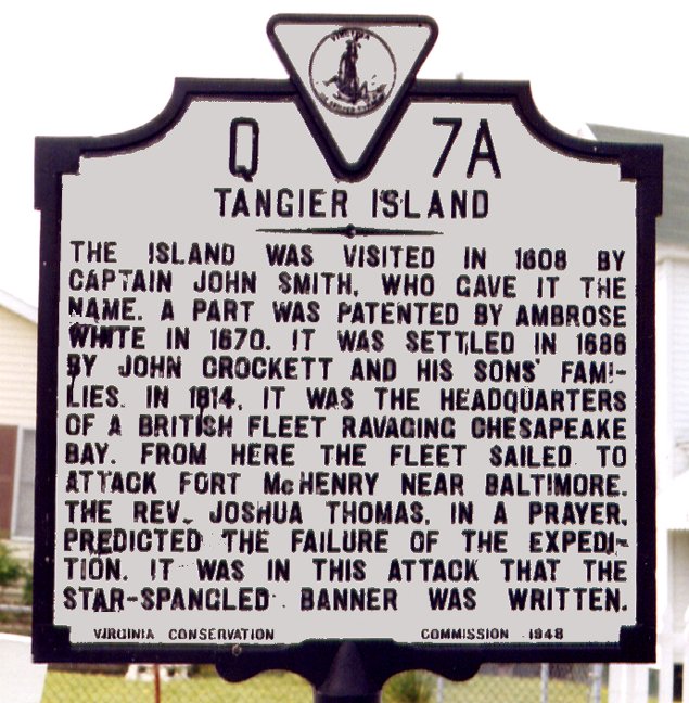
Tangier Island, as well as return again to Smith
Island. Tangier Island had been the number one
"to do" destination on my cruising agenda for
several years. But finding the right time and
circumstances had eluded me. Fortunately, my
wife, Margie, and I had been able to make the sail
across Tangier Sound to Smith Island last
year.
The natural beauty and remote unique character of
the island fascinated me. My eyes had been
opened and now I was hungry to venture further
offshore. I no longer considered the trip to
Tangier such a difficult challenge.
The eastern shore is different than any other place I've cruised. South of the Big Choptank River and the affluent boating meccas such as St. Michaels, Oxford, Tilghman Island and Cambridge, yachting centers become almost nonexistent--Crisfield being one of the few exceptions. But Crisfield is as much a working harbor as a place for pleasure boating, and doesn't ooze with the look of money like its northerly neighbors. This is seafood and fishing country. Sport fishing is big. The topography of the land is flat as a pancake with elevations not much higher than sea level. There are enormous marshlands, much of which are a national wildlife refuge and undeveloped. The whole area teems with wildlife--waterfowl and wetlands birds of every description are constantly on the wing, or visible hunting prey along the muddy shores and sandy banks of the marsh. Many species are unfamiliar to me, and I'm unable to call them by name. Wherever I've gone, Osprey have been nearby. They are entertaining to watch, keeping me occupied for hours at a time. On this cruise I was thrilled to encounter a pair of Bald Eagles, having them come closely overhead. There are also biting insects. The surrounding waters are very shallow and unsuitable for deep draft boats, except where navigable channels have been dredged at harbor entrances and in a few of the rivers. Cruising here, I'm frequently sailing in depths that are only three or four feet, so the centerboard hits often, but the bottom is either sand or mud causing little damage. There is a tidal range of about two feet. This is enough to create strong localized currents, which of course can be both helpful as well as a hindrance. It is important to pay attention to the tide schedule. The watermen, though, are accustomed to working in the shallow waters and are used to making frequent propeller replacements. In
my opinion the islands of Tangier and Smith best
exemplify the environment, history and way of life
of the eastern shore, or at least how it was until
recently. These two off-lying islands are also
integral to the huge tracts of marshlands that make
up the national wildlife preserves encompassing
portions of both Maryland's and Virginia's eastern
shore. Smith is in Maryland waters while
Tangier is in Virginia. Both support
year-round communities going back as far as the
first settlements following Captain John Smith's
exploration of the bay at the beginning of the 17th
century. They remain important centers of
watermen activity and are very interesting to visit,
offering amenities and attractions for excursion
boats as well as cruising boats.
In my musings I had anticipated going to Smith Island, the northerly of the two islands, first. It would entail a shorter open water passage, but involved taking the long narrow thorofare traversing the breadth of the island before reaching the town of Ewell. From Smith it would be an easy shot straight south to Tangier the following day. Where I'd go to after that, I had yet to determine. Half an hour passed, giving me time to attune to things. The westerly heading for Smith Island, still hidden below the horizon, developed to be a dead beat. I had nine nautical miles to go, four of which consisted of sailing up the narrow channel which was probably only fifty feet wide at the most, not a place for much tacking. While on a southwesterly tack pondering my dilemma, I noticed straight ahead, peeking over the horizon, a small speck that looked like a water tower. Could it be Tangier? According to the chart it probably was. Hey, a reach sure was a heck of a lot better than nine miles of beating. I locked onto the water tower, assumed a comfortable relaxed seat on the floorboards, and started to enjoy the cruise. At that point Tangier was a good 10 nautical miles away and it was 5:00 PM. Before long, the angle of the wind improved even more and Blue Mist clipped along easily at 4 or 5 knots. I was in luck! The top of the water tower grew bigger and was joined by a group of green smudges that were tree tops. I was going to make it. 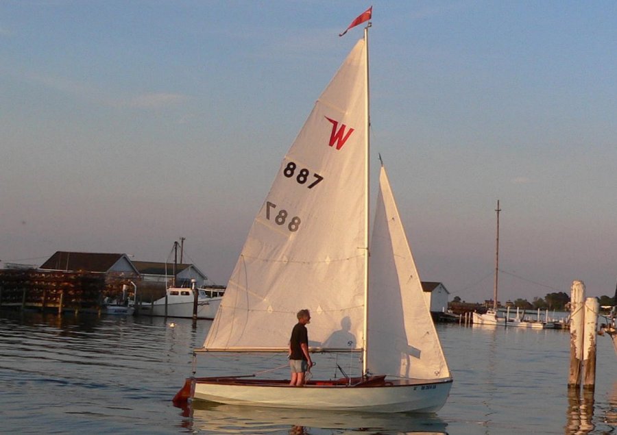 Luke
and Bobbie Huybrechts, sailing their yacht SV
Luna Sea out of Virginia,
e-mailed me a great photo. In the photo (above),
the sun is already dipping below the horizon, muted
tones of red from the western sky reflect splendidly
off Blue Mist's hull and
sails. It shows me as I ghost ever so gently
into Parks Marina at Tangier Island, with the last
few breaths of wind barely filling the Wayfarer's
sails.
On the dock, an impromptu welcoming party of cruising folks waited to greet me. Helping me warp Blue Mist into the oversize slip, I'm quickly drawn into a discussion. The conversation sort of went like "Nice landing… that's the first I've ever seen someone sail into this harbor." "What a beautiful boat… what is it?" I'd just refinished Blue Mist's hull and deck this spring and she was indeed looking pretty. Then the OH (Ohio) numbers on the bow are noted, resulting in the most frequent question "How did you get here?" Finally, from an informed and experienced sailor, "You've sure got a lot of faith leaving Crisfield at the time you did!" Then there was an invitation from the retired gentleman single-handling his restored 1960's Morgan 35: "When you're ready, drop by for a glass of wine and a chat." 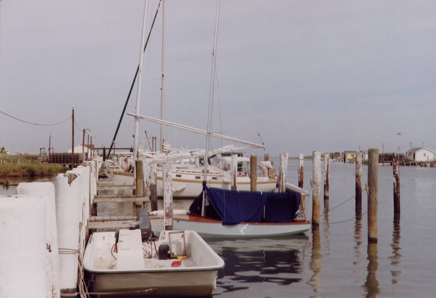 The
social hour was supposed to be limited as my host
intended to make an early morning departure.
But, of course, the bar never closed at the
designated nine o'clock hour. Sea stories
began to roll. I soon learned that my
friend would be spending the entire summer cruising
on the bay, retracing the track of Captain John
Smith's Chesapeake explorations. He had a
close acquaintance that was an historian and expert
on the subject, and he seemed to be well
informed. Out came a waterproof case
containing a thick photocopy of some kind of
manuscript, the beginnings of a book maybe.
Next was a large three-ring binder filled with
dozens of maps showing the many routes taken by
Smith during his exploration. Meanwhile,
having had nothing to eat other than a small snack
on the way over from Crisfield, I dug unabashedly
into an offering of delicious smoked whitefish pate,
crackers, and cocktail nuts, along with the
wine. My host's story was fascinating and I
was having fun learning about the Chesapeake's first
and most famous European explorer. Surely, in
some small way, I too would retrace parts of Captain
John Smith's track. What was surprising to me
and impressed my host as well, were the long
distances Smith was able to cover in a day.
Sailing a ship's boat known as a "shallop", a
two-masted launch around 20 to 25 feet long that was
also rowed, the explorer regularly covered 35
or more nautical miles in one day. At first I
refused to believe this claim, thinking that the
navigational measurements were faulty, or the
recordings overly optimistic. By modern
standards the "shallop" was a heavy, burdensome
vessel. It would have not been at all fast on
its feet under either sail or oars. But my
friend said no, the records have been carefully
researched and proven to be accurate and
authentic. Wow, I thought! The next time
I consider boasting about doing 20 miles in a day
with my much faster Wayfarer, I need to remind
myself of John Smith. When I awoke the next morning,
my friend was already off pursuing John Smith's
legacy - headed up the Pocomoke River, known for
being the most beautiful, pristine and longest
navigable river on the eastern shore. We would
meet one more time, but just briefly.
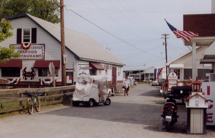
 Seventy-four-year-old waterman, Milton Parks, who still gets up at 5:00 AM to go catch crabs, is the owner and operator of the one marina on Tangier Island. Parks, with a mischievous grin, enjoys telling new arrivals that he owns the only brick house on the island. Life on the island is simple. Houses are built close together and the streets are narrow--there are no automobiles or trucks. It is not uncommon to see a burial plot in the front yard of a house because land is precious. Practically nothing on the island is more than a foot or two above sea level and many structures are built upon piles over water. To get someplace, one either needs a good boat or relies upon the ferry. 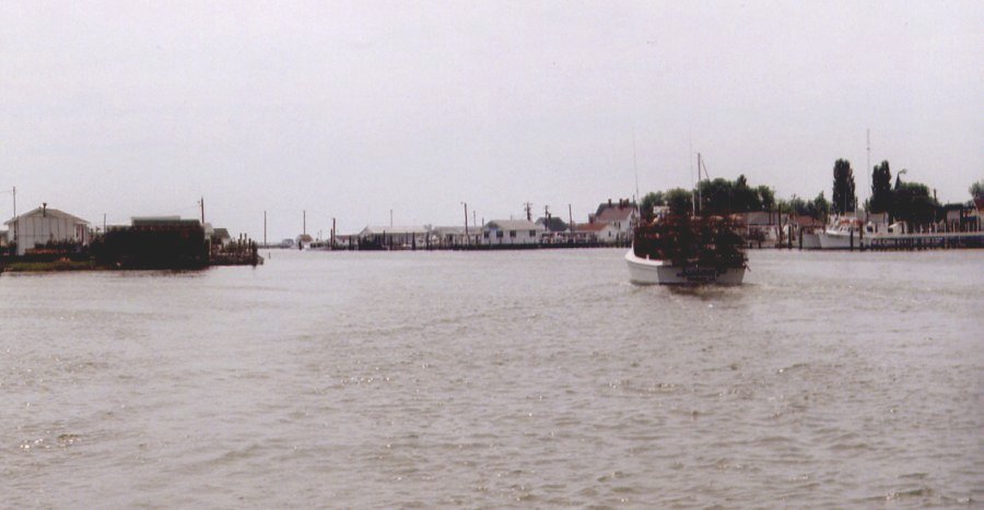 Entering
and maneuvering within the harbors on both Tangier
and Smith islands requires skill and having your
wits about you. It is no time for laxity. I
have had my share of difficulties at both
places. To give you a taste of what I mean,
I'll relate an experience I had Tuesday evening when
first entering Tangier harbor.
Like
many of the harbors on the eastern shore, the harbor
appears to be larger than it really is.
Actually, most of the water is but a foot or two
deep. Impossible to find, were it not for
navigation markers, is a narrow dredged
channel. A jumble of piers and shanties built
upon piles, combined with dozens of power poles set
in the water with wires strung in all directions,
create a puzzle to the eye. As a result I made
a mistake which could have cost me dearly.
This was one time that sailing a centerboard boat
and straying out of the main channel got me into
trouble. It was classic bad judgment!
 I
was confused and it was getting late. First, I
lost track of the channel markers. Struggling,
with just an occasional breath of wind, I decided to
go cross-country with the board up rather
than back track.
Then, in the back of the harbor, I spotted half a
dozen masts, telling me that should be the
marina. With the wind, or what there was of
it, behind me, I mostly drifted over the shallows in
the direction of the masts. Though surrounded
by water, ahead stood a bunch of power poles with
low hanging wires-power lines to the numerous live
crab holding pens on the piers. I was
apprehensive, but convinced myself I would be able
maneuver around the wires. I was wrong; the
wires were lower than they looked. Too late I
found myself trapped, with Blue
Mist's mast lying up against a power
pole--alongside a live transformer and wires!
I braced for the flash, which for some reason didn't
come. With the wind light, I managed to push
off and gingerly work my way out of the maze.
Escaping that mess without suffering any
consequences was truly a blessing. I'm sure I
said a sailor's prayer of thanksgiving. Did I
learn anything? The answer is yes.
 Wednesday
morning, following a simple on board breakfast, I
had the pleasure of meeting and chatting with both
the Huybrechts and Milton Parks. Luke and
Bobbie Huybrechts are a very nice couple and
surprised me when they said they'd taken photos of
my arrival. If I'd give them my e-mail address
they would send me the pictures. What a
delightful and friendly gesture! Later, as I
wrote this story, I was very happy to get those
pictures - they turned out much nicer than I
anticipated.
Parks is a gem of a character - the kind of guy you hope to meet at a place like Tangier. Full of stories and advice, there are no airs about him. If the rest of the folks on the island are as content and easy going as he appears to be, life on the island must be good. I think it is, because to me, everyone seemed very friendly and cordial. Parks' rate for boats 30 feet and under is $25 per day, but he insisted that I pay only $10. That was a good start! We talked some about my adventures and cruise plans. I'm sure he was checking me out. Was I really qualified to be there or not? We discussed the weather on the bay and how summer thunderstorms can pop up with little notice. I told him about my mishap when I capsized in a sudden thunderstorm off Crisfield Harbor seven years ago, and how the watermen had pulled me out of the drink. It was another case of faulty judgment. I had ignored the warning signs. He was surprised and cautioned me to be careful. That brought the conversation around to a recent tragedy--the loss of a fellow waterman from Tangier during a severe storm this past winter. I had heard a few scraps of the story--it had made big news locally. With the wind blowing over 50 knots, the waterman should have known better than to be out there. His body still hadn't been found and no one knows where the boat is. I suspect Parks is one of the more prominent island residents. I'm happy I got to meet him and look forward to my next visit. A change in the weather, rain and thunderstorms, was forecast for Thursday through Friday. Friday looked like it would be a non-sailing day. This posed a problem. Back home, just before departing, the local city court magistrate had thrown a monkey wrench into my plans. I'd received a summons for jury duty for the following week - maybe! I had to phone the court clerk Thursday to find out if I really needed to show up. Thankfully it turned out that I didn't. But having no way of knowing until Thursday whether or not I would be pulling Blue Mist out on the weekend left me with no choice. I needed to return to Crisfield before bad weather set in. There were just a couple of hours to take a quick look around Tangier, after which I had better be heading north for Smith Island. From there, hopefully on Thursday morning, I'd be able to make it across Tangier Sound to Crisfield. It would have been nice to have more time on Tangier Island, but the chance of getting stuck on one of the islands was too great. The
wind was southeast at 15 knots. It would be a
broad reach under a lee shore and a hot hazy
sky. Heading out the west harbor entrance into
the wide open bay, opposite the way I came in, Blue
Mist flew over the waves at
5 to 6 knots. On my second day out I already
had my sea legs beneath me. The passage to
Smith Island was enjoyably relaxing and quick.
The crowning statement came as I pulled into the slip at the marina in Ewell. One of two guys on a 30-foot Nonsuch, who'd left Tangier just ahead of me, couldn't believe his eyes. "How in the world did you get here so fast?" he asked. I had sailed in right behind them. I just grinned. Part Two
The southern part of Maryland's Eastern Shore, south
of St. Michaels,
Oxford and Cambridge, is my secret cruising
ground. The water is
thin and best suited for smaller power boats and the
well-known
watermen's boats. It is possible for shallow
draft sailboats and
motor yachts to cruise these waters if they're
careful. However,
few
do. The shore consists of thousands of acres
of marshland that is
inundated with broad, quiet rivers. There are
no straight lines
along this shore--it is a ragged coast. Much
of the marsh is
designated as federal wildlife sanctuaries,
undeveloped and in a state
much as it would have been when Captain John Smith
first explored the
Chesapeake. The Chesapeake is about 20
nautical miles wide at
this point.
The multitude of expensive yachts berthed in marinas along the overdeveloped west shore rarely makes it to the southern part of the Eastern Shore. Except for the harbor at Crisfield, there is a dearth of plush marinas and amenities required for "comfortable" cruising. Most of this part of the Chesapeake is considered unsuitable for cruising. It is best known for being the bountiful source for a prosperous seafood industry and outstanding sport fishing. For me, it has been a marvelous place for dinghy cruising. I had departed Crisfield on Tuesday, May 31, 2005. The weather had immediately turned from cool spring to full summer and it was very warm. Fair winds had prevailed and the sailing was fast and fun. My most important cruise objective, sailing to remote Tangier Island, had gone better than I'd hoped. Tangier didn't disappoint me - it was an absolutely charming and intriguing island. The vibrant waterman community there has no equal anywhere else on the Chesapeake. This was the realization of a dream I had nurtured and anticipated for a long time. Unfortunately, impending bad weather forced me to cut my stay short. 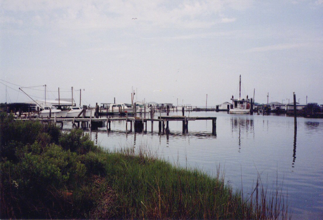
The next day, Wednesday, I sailed to Tangier's big
sister to the north,
Smith Island. Smith Island also supports a
year-round population
of watermen, consisting of three separate
villages. It likewise
presents a fascinating place for a stopover.
Most notably, the
island is largely marshland and hosts an amazing
array of wildlife that
would make any naturalist drool.
That had been the extent of my planning. The
next page of the
cruising itinerary was blank. Though there
were places I'd been
to before that beckoned to me, such as out of the
way pretty coves
further north around the Hooper Islands, I'd rather
explore anew.
A plan began to form in my mind. My friend
with the 1960's
Morgan 35, whom I'd met in Tangier, had given me an
inspiration.
He had shown me a loose-leaf binder containing a
dozen or so crude
maps. They were copies of documents prepared
by John Smith's
party from their first exploration of the
Chesapeake. He related
to me his intention of spending much of the summer
retracing Smith's
travels. Included in the maps were
descriptions of the
explorations of rivers in the immediate
vicinity. The following
day, he would be headed up the Pocomoke River, the
longest of the
Chesapeake's navigable rivers. Far
removed from normal
paths of travel, it is reputed to be the most
pristine and beautiful of
all the rivers.
For me, the Pocomoke River was not a viable
option. The approach
is through an expansive 14-mile long bay, Pocomoke
Sound.
Besides being huge, it is extremely shallow and
offers minimal
protection. Adding to the difficulty, the
final four or five
miles would require staying within the confines of
the "ditch", the
nickname for the long and narrow dredged channel
that runs half way
across the Sound. It would be a dangerous
place to be caught out
in a storm. I studied the chart for other
prospects.
North of Crisfield four big rivers enter Tangier Sound--the Big Annemessex, the Manokin, the Wicomico and the Nanticoke rivers. Of them, the latter three are deep within the heart of vast marshlands. I saw numerous creeks and bays that could easily offer an attractive overnight anchorage. I had my plan. First,
before anything
could happen, I needed to get back to
Crisfield. Was the magistrate back home
going to make me end my
cruise and return for
jury duty? A
phone call to the city court
clerk Thursday afternoon would tell the
tale.
Thursday morning when I awoke at Captain Steve's
marina in the town of
Ewell on Smith Island, the weather was
deteriorating. The sky was
gray and it was blowing. Checking the
forecast, the wind
prediction was 15 knots out of the southeast and
increasing to 20 in
the afternoon. But looking at the flag
whipping across the
channel I figured it was blowing close to 20
already. Rain was
expected by noon, accompanied by possible
thunderstorms. A
sizable system was moving in and I needed to think
things over.
Next door at the combination general store, gas dock and coffee shop, four men sat talking around an oversized breakfast table. They invited me to join them. Three were watermen and one was the island's pastor, who it turned out was relatively new and from my home state of Ohio. It occurred to me that coming from the Midwest to serve the congregation of this unique island community had to be quite a cultural shock. Nevertheless, the preacher seemed to fit right in with life on the island. I was envious. It was a brief opportunity to learn a little more about the island. Soon, however, I was checking for advice. "The small 16-foot sailboat in the marina is mine," I explained. "I'm contemplating making the trip across to Crisfield. I'm wondering what the conditions will be like out there?" I added. The distance across Tangier Sound is only five nautical miles, but my problem was more complicated. Ewell, being situated on the west side of the island, is at the far end of a narrow and winding 3-1/2 mile thoroughfare connecting to Tangier Sound. Headed east without a motor, it would be a beat the entire way down the channel. I was nervous about capsizing. What if I buried the centerboard in the mud, as I had done more than once the day before, coming in the west entrance? It could mean serious trouble. "You need a motor," they advised. The good news was that they didn't think I needed to worry about the threat of thunderstorms. It was then or never, so I decided to give it a try. Initially raising the genoa and seeing it flog, I switched to the smaller storm jib. I then put a reef in the main. A local who is also an owner of a small sailboat dropped by to see what I was up to. I explained my predicament. "I've decided to go back out the west entrance and around the north end of the island through Kedges Straits," I said. It was a lot longer, but I felt that I had no other choice. Kedges Straits is the passage between Smith Island and South Marsh Island, which is the next large island to the north in the string of north-south islands that form Tangier Sound. South Marsh has no dry ground and is uninhabited. It is strictly a wildlife preserve. "If you had a motor you could go out the other way," he observed, but seemed to agree with my plan. His parting words were less than comforting. "The seas tend to build up in Kedges Straits," he warned. In the lee of the island the sailing was easy, though I was glad to have reduced sail. Rounding the northern end of the island and coming onto a beat, everything abruptly changed. The head seas kept getting bigger and it seemed that Blue Mist was barely making headway. This was the roughest water I'd experienced for some time. The Wayfarer's foredeck began to catch the top of an occasional five-footer, lifting buckets of water across the deck and into the cockpit. Sheets of spray doused my glasses and it began to rain. I was fully dressed in foul weather gear, including boots, and comfortable enough, yet with my visibility so restricted, a watery world closed in around me. My concentration was completely focused on the next oncoming wave. With the slop in the bottom of the boat rising I dreaded the thought of possibly having to heave to and bail. After what seemed like hours, the buoy marking the east entrance to the Straits was far enough aft that I felt I could switch to a port tack. For some reason, maybe because the Straits were gradually falling astern, this resulted in an improvement. Blue Mist took on less water and seemed to make better progress. Approaching the mainland on the opposite side of Tangier Sound, the waves diminished. Even in the rain I could breathe a sigh of relief. Much happier now and entering Crisfield Harbor at full bore, I couldn't resist the temptation to show off - the cause of some embarrassing blunders in the past. This time, however, there were no slip-ups and Blue Mist rounded up cleanly into the slip with nary a bump. Regardless of whether anyone was watching, I knew she looked sharp. The crossing of 14 nautical miles had taken 4-1/2 hours and though it was still early, I celebrated with a couple of stiff swallows from the whiskey flask. An anchor dram well earned, my friend Ken Jensen from Norway would have said! 
As a tourist destination the town of Crisfield is
somewhat
lacking. Unquestionably, the most popular
attractions are the
excursion boats making daily trips to Tangier and
Smith islands.
Complementing this is a maritime museum, a handful
of small shops and
about four restaurants. The modern marina,
consisting of several
hundred slips, takes up the majority of the harbor.
It is
operated by the city of Crisfield. Included
are about 50
transient berths with excellent facilities for
visiting boats.
When I arrived the visitors' area was practically
deserted, with less
than half a dozen boats moored in slips. The
phone call home brought welcomed news - there was no
need to report
for jury duty. Relieved and excited, I was
free to pursue my
plans the following week.
It rained and blew all day Friday, yet in spite of the weather there was going to be a bash! By late afternoon it became apparent something was happening. One after another, a group of eight or so palatial yachts began arriving. The new arrivals were from Virginia's opposite shore. Normally I despise motor yachts, but three of these were a classic, sleek-looking model grandly finished with generous amounts of teak and chrome. They were handsomely built craft and obviously quite special. The others consisted of the usual floating plastic castles, with flying bridges 25 feet in the air - rather ugly in my opinion. I was thankful that I had chosen an out of the way corner for Blue Mist and wasn't next to this crowd. I watched as a catering company arrived and set up tables with white tablecloths, a bar and a food serving area in the large pavilion next to me. Soon after that, a band arrived. Cocktail hour began with the ladies descending from their yachts, wearing fine jewelry and fancy dresses. The party had begun. It was diversion from an otherwise boring evening to watch the dancers and listen to the music. The noise was not all that disturbing, considering that after dinner at the restaurant there were few entertainment options available to a lone dinghy sailor on a damp evening. On the other hand, I certainly felt out of place and was anxious to be on my way. By midnight, with the alcohol enhanced laughter finally subsiding, the party broke up. "See you again next year," I heard the band leader say. On Saturday morning the weather was clearing. By the time the wealthy party-goers were starting their catered breakfast, which included reopening the bar, Blue Mist was packed and I was raising sail. The genoa went up, but then with a dull snap, dropped to the deck in a heap. The wire halyard had separated at the thimble connecting to the attachment hook. I stared at the frayed strands of wire in dismay and disgust. There was no way out. I needed a new halyard. What bothered me most though, was the thought of having to thread the new wire through the mast--a task I'd struggled with before. No one, neither the marine boat dealer nor the two hardware/marine stores in town, had stainless wire. There wasn't even any suitable double-braided line to use as a substitute. "I can't believe this!" I exclaimed. "This is fishing and power boat country--we don't deal much with sailboats," they countered. "Try Boater's World in Salisbury." Two hours later I returned from Boater's World with a replacement rope halyard. They couldn't supply wire, either, as they weren't "licensed" to work with wire. It would have to be specially ordered from Chicago.
Turning Blue Mist around in the slip, I
managed to drop the
mast onto
the dock. By then I was a curiosity. One
more time I
trudged to the hardware stores, this time looking
for thin wire to fish
through the mast. Back again, I had now gained
an audience.
Two college-aged girls working the marina desk
stopped by, brightening
my spirits. I put them to work helping me with
the frustrating
task of fishing the rope through the mast.
After a number of
failed attempts we finally succeeded.
It was 4:30 P.M. when I looked at my watch--another late departure. I was just glad to be out of there. The day had turned out gorgeous, except that before long the wind faded to next to nothing. As the sun dropped toward the horizon, becoming a huge, golden globe, I settled in for a long sail. The sea was still and the sunset marvelous. Finally relaxed after a frustrating day, I was enjoying the peace of being alone on the bay. Sitting on Blue Mist's floor, my back resting against the aft bulkhead, I kept the boat heeled slightly to leeward. The Wayfarer slowly drifted northward, pushed by the tide and an occasional zephyr. Ahead lay the tip of the long point separating the Big Annemessex and Manokin rivers. Behind the point was a small and shallow protected bay called Mine Creek. It looked attractive. With the arrival of dusk, while continuing to sail, I retrieved the stove from the aft compartment and boiled water for dinner. A bowl of my favorite gourmet dried soup and a tasty stuffed potato served as the main course. The time had passed quickly. With darkness descending I was able to pick out the red flashes of the buoy off the point. I plugged in Blue Mist's masthead light. Gradually a pleasant evening breeze materialized and quickly Blue Mist began to close in on her destination. On such a pleasant summer evening, clear and bright, it was a sail to remember. 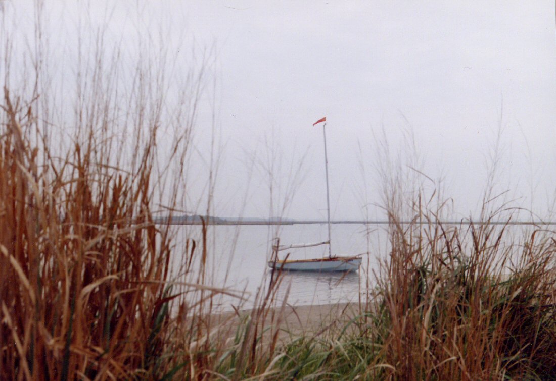 Mine Creek is actually a large cove formed by a low lying island within the marsh on the end of the point. There is no evidence of a creek. The depth in the middle is only three feet. Except for a couple of houses on the mainland and a wharf where watermen have crab holding pens, the area is a wilderness. Feeling my way in the dark, I worked Blue Mist across a sandbar and close to the shore, trying to keep a foot or two of water beneath her keel. Peacefully tucked within the shadows of the island and away from any signs of civilization, I was very content. The sun was shining brightly when I awoke Sunday morning. Inside the boom tent it was too warm. Outside, the marsh was alive with egrets, great blue herons, pelicans and other shore birds that I'm unfamiliar with. The sand along the shore's edge was the stage for many of these actors. High overhead, a pair of ever-present osprey circled and cried out to each other while hunting for fish. This is one of God's beautiful creations. Upon going ashore after breakfast, however, I'm able to stay only briefly. The biting insects are ferocious! 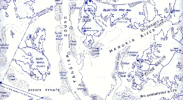 The morning breeze is light as I head north into the wide bay constituting the mouth of the Manokin River. The sun is intense, calling for lots of sunscreen. But the hot weather is just beginning. It will become unseasonably warm as the week progresses. The sky to the east along the Atlantic shore is building big banks of tall cumulus clouds, but on the bay it is clear. With the wind blowing, the heat is tolerable. Noontime rolls around and the south wind has increased to 10 to 12 knots. Blue Mist is scurrying toward her first port of call for the day, a small creek five miles back in the bay called St. Peter's Creek. The chart seems to indicate a couple of docks and there are roads in the vicinity. I sense that there is habitation and maybe a store. By now I've developed a craving for some good Maryland crab cakes and am thinking how great it would be if there should be a restaurant. I've also concluded that my on-board food selection is too limited and needs a shot in the arm. What I had packed was more or less for emergencies--my intention being to partake of Maryland's wonderful seafood whenever possible. I would learn that this wasn't easily accomplished. 
For all practical purposes, the Manokin River is
just a large
bay.
It is surrounded by the lush greenery of the marsh
and wooded
lots. I would scarcely see more than half a
dozen boats on the
water. Rarely is a house visible as they are
set far back from
the water's edge. The countryside is
rural. Approaching St.
Peter's Creek was interesting and fun. The
channel twists and
turns abruptly around the sandbars blocking the
entrance, making it
necessary to pay close attention to the channel
buoys. Inside the
creek the scene is that of a small and picturesque
country
river. A short distance up the river is the
public boat
ramp. I land Blue Mist alongside the
small narrow dock,
once
again feeling like a grand adventurer. An
older couple out
fishing for the morning arrived behind me. I
ask how they did and
the husband shows me a cooler partly filled with
large, nice looking
fish that he calls croakers. The fishing is
fantastic he says.
Even though it is Sunday and the day is gorgeous, the place is essentially deserted except for a handful of fishermen. There is nothing resembling a store or restaurant. A few houses line the road connecting the launch area to the main shore road. A man shows up to launch a small, plastic sailing dinghy, but he doesn't seem to take any interest in my Wayfarer. I ask him about a store and he says that there's one a mile or so down the shore road. The countryside is sleepy and isolated. Walking in the sweltering heat I haven't seen anyone, let alone a store. After half an hour I turn back. Leaving St. Peter's Creek, I set a course for Deal Island harbor, first backtracking to Tangier Sound and then turning north to the tip of the next big peninsula jutting far out into the bay. It is a distance of about 12 nautical miles. The whole way out to the Sound was a beat and the afternoon was waning. I'd tarried too long at pretty St. Peter's Creek. Finally clear of the big sands lying off Little Deal Island, I headed north. The wind was beginning to die. Behind Little Deal Island there's a nice looking harbor but, still thinking about that seafood dinner, I passed it by, continuing on for the bigger Deal Island harbor. There's bound to be something there, I assured myself. The last two miles would take over an hour and a half. At 7:00 P.M. and frustrated, I arrived to disappointment. Partially blocking the harbor entrance was a huge dredge in full operation. The racket was terrible, with big diesel engines droning loudly and the mammoth machine rumbling and clanking constantly. Joining the chorus were several work boats charged with moving barges and pipelines back and forth. The operation would run around the clock, meaning no peace that night.
Deal Island's harbor is not very large, nor is it
picturesque.
However, it is typical of some of the working
harbors on this part of
the bay. With the Chesapeake fishery in slow
decline, a result of
pressure on the ecology from development and
pollution, the harbor
reflects evidence of better times. The once
upon a time
restaurant, long ago fenced in, is falling down and
surrounded by
brush. Pilings of an abandoned marina, long
silted in, protrude
from the muddy bottom of the harbor leaning at crazy
angles. The
walkways have long ago disintegrated. Yet, a
number of watermen
continue to work out of here and there remains a
small, prosperous
seafood packing plant that employs half a dozen
people. The area
is far off the main track, so tourism is
nonexistent. Unlike
Tangier and Smith islands, these mainland harbors
don't promote
thriving
communities. The typical waterman arrives at
his boat by 5:00
A.M. and returns by 2:00 or 3:00 P.M. to meet the
seafood trucks
waiting on the pier to buy his crabs. By 4:00
P.M., having gotten
his boat and gear in shape for the next day, he
melts back into the
countryside. The harbor once again becomes
quiet and deserted.
In the morning, I rowed across to the seafood plant, cautiously tying up to the rough pilings. Before I could complete the job, two men were standing anxiously above me trying to assist. One, a big, burly black man, smiled from ear to ear and greeted me like a long lost friend. "It's nice to see you again," he says. I was at a loss. "I'm the guy who talked to you yesterday at St. Peter's Creek," he reminded me. Meanwhile, Blue Mist was receiving admiring looks, punctuated by questions about what this thing and that are for. The man continued, "The boss has a sailboat--sort of like yours. It is homemade and built out of aluminum." I should come inside as he would want to talk to me, I was told. "Okay," I said. "Can I get some drinking water?" I ask. "Yes, but it tastes awful and you won't like it!" was the reply. "Where's a store?" I added. There was a small store over the high bridge about half a mile down the road, I was informed. 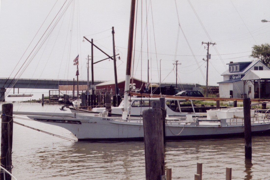
Inside the packing plant four black workers were
spread around a large,
stainless steel table with a pile of crabs in the
middle. They
were the soft shell variety which are cooked and
eaten whole, usually
breaded and deep fried or sautéed with seasonings.
They
are a heavenly delicacy, provided you don't think
about what you're
eating. The conversation continued as the
workers carefully and
neatly wrapped the individual crabs, still alive, in
a plastic sheet
before tucking them into a fancy cardboard box. Each
box held two
dozen crabs. When the box was full, the
manager checked it before
sealing it and placing it into a walk-in
freezer. My mouth
watered at the thought of enjoying a couple of those
for lunch, but I
had no means of keeping them alive. "These crabs
will be shipped
all over the country," the friendly guy
spouts. He is proud of
his job and wants me to take pictures, but inside
the plant the
lighting is not good. I also learned that in
the winter months he
worked harvesting oysters on the big Skipjack,
moored in a nearby
berth (see photo above). "That's tough
work," I say,
expressing admiration for
those few watermen who still man these famous old
sail-driven
Chesapeake
Bay boats. He tells me that I would have no
trouble handling the
big Skipjack, with its monstrous mainsail, but I
disagree. The
boss and I take a look at the aluminum
sailboat. The welding is
nicely done, but the beam is narrow and I see other
bothersome design
flaws. I learn that he didn't build the boat
and seldom sails
it. I give a few tips that might be helpful,
but keep most
of my thoughts to myself. "Always wear your
life jacket," I
suggest.
The drinking water is full of iron, rust-colored, very salty and unbearably bad. I vow to conserve my little bit of remaining good water just for drinking. Following my experience the day before, I decide not to look for the store, but instead be on my way. After taking pictures of the handsome Skipjack, I head back out past the dredging operation and am glad to be done with Deal Island. The weather forecast is identical to the day before. The prediction for possible afternoon thunderstorms along the Atlantic shore doesn't concern me. 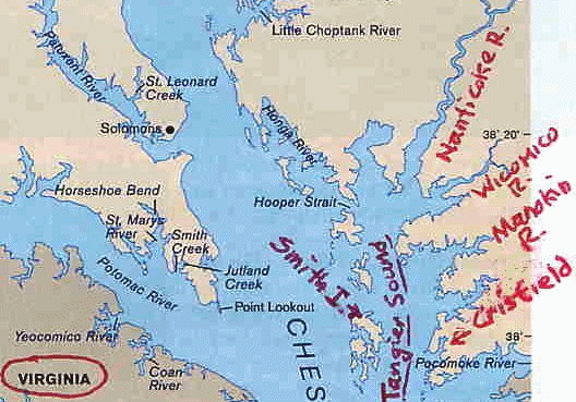
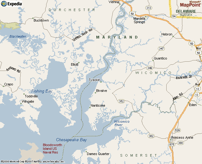
Over the next three days I would relish exploring
both the Wicomico and
Nanticoke rivers. The ragged nature of this
coast presented an
ever changing scene, dispelling any chance of
boredom. The
greenery along the shore, lack of commercial
development and sparse
boating activity, generated a feeling of
adventure. It wasn't
difficult to imagine how the area might have looked
back when Captain
John Smith first arrived. Both rivers are full
of crooks and
bends, offering new vistas with each turn of the
channel. Bites
in the rivers, as well as tiny side bays, offer
places for pleasant
anchorages. There is an occasional house along
the shore, but
they are scattered and frequently hidden from view.
The day is Monday. Blue Mist is headed for the upper parts of the Wicomico River. A southwest breeze is kicking up small whitecaps as she skims over the waves, wing on wing. Seven miles up river lies the village of Whitehaven. It looks like something straight out of the New England countryside. Surprisingly, the village shows signs of catering to tourism. Among the row of brightly painted, two-story wood frame houses exhibiting bits of Victorian architecture, is a Bread and Breakfast. There is also a museum and gift shop. Adding to the charm is a small cable ferry busily taking cars and trucks back and forth across the river, something I've not seen before in these parts. Whitehaven is probably the prettiest little town in this entire region. Unfortunately, there are no stores or restaurants. 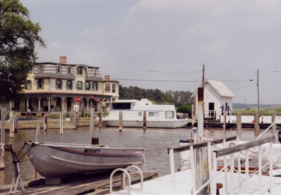
Landing at the dock of the one and only marina,
which was deserted, I
admired the quaint village. While in the
process of taking photos
I made a friend, a retired naval airman and widower
named Frank
Bennie. He told me that while still flying he
had scoured the
whole eastern peninsula from the air and concluded
that Whitehaven was
where he wanted to live after retiring. The two of
us visited for
a long time. Before leaving, Mr. Bennie loaded
me up with enough
groceries to keep me going for the next couple of
days. To say
the least, I think he's a great guy.
Now each day is filled with sunshine. By afternoon the temperatures are uncomfortably high, making me very thirsty. The warm tasteless water on the boat doesn't provide satisfaction. The cool, sweet water from the marina comes as a godsend. Water never tasted so delicious. Happily I dumped the terrible stuff from Deal Island and refilled my jug. Next, employing the bucket in the boat, I was ready for a much needed and refreshing bath. The time had come to get going. Returning part way down the river in conditions that were now gusty, I anchored in a bite in the river. It promised decent protection and was a peaceful spot with no houses nearby. Strong thunderstorms were forecast for that evening. The thunderstorm was undoubtedly the most severe I've encountered while on Blue Mist. Three different lines of storms came through, one, then another, and finally another lasting late into the night. The first was the worst. The leading wall of wind arrived accompanied by an eerie, high-pitched howl. It was unsettling. The initial gusts had to be at least 40, possibly 50 knots. Looking out the forward windows of the boom tent I saw a river that was a mass of foam and whitecaps. Rapid successions of staggering lightning bolts, with deafening claps of thunder, lit up the river. The wind came straight up the river and I was exposed to its full fury. Blue Mist began to veer wildly back and forth on her anchor rode, with the waves rushing beneath, rocking her sharply. Sheets of spray came over the bow, through the windows and into the cockpit. I was forced to button them down to avoid getting everything inside soaked. No longer could I see what was happening, but was far from insulated from the storm's rage. Inside, the tent lights up with every flash of lightning, while I brace myself rigidly against the aft bulkhead as the boat literally jumps sideways over the waves. Is the wind getting underneath the hull and lifting it? For the first time in my life I wonder - will Blue Mist be flipped on her anchor? But God is good! The rain arrives in torrents. It adds to the chaos, but at the same time breaks the back of the wind. Inside the cockpit I'm wet and uncomfortable, yet relieved, knowing that Blue Mist will survive. Nevertheless it is a long night. Tuesday morning the sun was back. With my wet sleeping bag flying from the spreaders, possibly looking like some sort of distress signal, I received a visit from a woman and her young son. They were paddling two kayaks. I'm surprised. I had met them at a small nearby marina the day before. The boy's name is Hunter. "I was worried about you last night," the woman confessed. "My husband and I could see you from the house, but when the storm came in, we couldn't tell if you were all right." "I was pretty damp but otherwise okay," I assured her. Next was a really sweet surprise. "Hunter and I brought you breakfast," she said. My jaw must have dropped. "Wow, that is really kind of you," I said. I had already eaten, so I begged permission to save the delicious pasta and fruit salad for lunch. With the three of us in our boats out on the river, I explained all about my travels and about the Wayfarer. When they learned that I was down to my last bottle of beer, I was invited to stop at their dock before departing. There, Hunter ran out with a couple bottles of Corona. The generosity was too much. "Come on, let me take you two for a sail," I offered. Hunter was all set to jump in, but sadly, mom had another appointment. Happy to have been treated so kindly, I smiled and waved, then turned down river. Only a few miles to the north lay the next big river.
The Nanticoke River flows practically due
south. Upriver, the
area to the west consists of thousands of acres of
low lying
marsh. It is a national wildlife refuge. Here
the water is
very shallow and for a long way out, the depths are
hardly more than
three
or four feet. This is a favorite area for
crabbing and I often
saw five or six watermen working in the
vicinity. Similar to its
neighboring rivers to the south, the mouth of the
Nanticoke consists of
a broad bay. On the east side of the bay the
ground is higher and
more developed. This side has a couple of good
harbors, the
principal one being at the town of Nanticoke.
Still half a mile out from the harbor, I detected the smell of fried seafood wafting across the water. It was tantalizing yet strange. Sailing into Nanticoke Harbor I discovered the source. Behind the breakwall is a seafood plant where shrimp and clam strips are processed. Nanticoke is another working harbor that is also shared by a small number of pleasure craft. Though interesting and a good refuge, it is hardly pretty. Except for the waterfront park, there is little in the way of shoreside facilities. Circling the cramped harbor performing my best close quarters maneuvering, jibing and tacking, I heard a man shout. It came from a group of watermen tending to their boats. "Hey, Jim, do you think you can do that?" were the words I seemed to hear. Pleased, I felt that I had been given a welcome. After tying up at the spacious public landing, I managed to catch up with one of the watermen. It was still in the middle of the afternoon and I was hopeful. Did he have any crabs left? "Sorry, but no," was the reply. The trucks had just left, taking everything with them. No crabs again!
Thanks to the activities of the watermen waking me,
Wednesday morning
got off to an early start. Running before a
pleasant southerly
breeze, I easily sailed a considerable way up the
Nanticoke
River.
There the river narrows and meanders, while the high
ground to the east
gives way to marshland. There wasn't
a soul around. I'm within a couple miles of
the big electric
generating station located near the main highway,
Route 50, when I
decide it's time to turn back. The afternoon
is still early, but
the next day I want to return to Crisfield. I
feel the
need to begin backtracking.
Soon after departing Nanticoke, I had begun to look
for a place to come
back
to for the night. On the chart was a tiny
feature, just a
squiggle in the shoreline, which caught my
interest. A thin blue
line
marked Wetipquin Creek flows into a small bay on the
east shore.
The single sounding shows one foot. In the
morning I had been
unable to distinguish the location. Now
returning, I wondered if
I had again passed it by. Not until I sailed
very close was I
able to pick out the bay. Coming in, I
grudgingly eyed a cluster
of homes and power boats on moorings to my
right. Just as my
spirits were beginning to falter, I noticed to the
left, an open
stretch
of beach previously hidden from view. Beyond
that was marsh where
undoubtedly lay the creek. There appeared to
be no houses.
Jutting out from the shore was a large wooden
structure. Closer inspection revealed it to be
an old decaying
pier. I was baffled. What was this
place? Avoiding a
couple of sunken pilings, I landed Blue Mist
on the pier and
went
ashore. What a heavenly surprise! I had
stumbled upon the
town park of Tyaskin. It was beautiful and
quiet. There
wasn't a soul to be seen.
The rest of my afternoon was spent just hanging around the park and enjoying the beach. I could tell that people loved this park. It was clean and well cared for. A memorial plaque, dedicated to the couple who had donated the land, exhibited some old photos. One was taken in 1907 and showed a large fishing schooner moored at the old wharf. The place was bustling and a group of buildings had stood where the park was now. A woman stopped by briefly. Parking her car in the small lot, she removed her shoes and strolled along the sandy beach and in the water, letting the fine sand sift between her toes. Then she was on her way again. Next along are a young family with two small children and a grandmother. They take a picnic out to the end of the old wharf and try their hand at some fishing and crabbing. The family leaves and I'm alone briefly before six children just out of school show up on bikes and in bathing suits. The noise level escalates. Now the wharf changes into a perfect platform for jumping and diving into the cool waters on a hot day. The swimmers continue for hours until the kids are joined by a couple of dog owners, who also encourage their pets to jump off the wharf. Sitting at a picnic table beneath a pavilion, I'm happily entertained just watching all the fun. A couple hundred yards down the shore is Wetipquin Creek. It is perfect and just wide enough for the Wayfarer. The sun drops low as I set up the boom tent for the evening. Big fish are feeding at the mouth of the creek. Their activity creates miniature whirlpools on the water's surface. Earlier, a pair of magnificent bald eagles flew directly overhead. It all reminds me how the wildlife is amazingly abundant and awesome here. That night I thanked God for so generously sharing his beauty with me. I also prayed that Tyaskin Park stays forever just the way it was that day - an unspoiled gem enjoyed by the local children and stumbled upon by a wayward adventurer sailing the shores of the Chesapeake in his Wayfarer. The End
|